


UNESCO adopted the 'Convention Concerning the Protection of the World Cultural and Natural Heritage' at the General Conference in 1972, and began to designate World Heritage Sites of outstanding universal value to be preserved for all humanity. Jeju Volcanic Island and Lava Tubes is Korea's first and only properties to be designated as World Natural Heritage Sites (2007).
Mt. Halla, the Highest Holy Mountain in South Korea
 |
Address : 3096-7 1100-ro, Jeju-si, Jeju-do (Nohyung-dong)
|
||
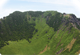
| Hallasan Mountain is one of Korea's three most famous peaks, and it is the highest mountain in South Korea. It is home to a variety of flora and fauna, some of which is threatened with extinction in South Korea and therefore under special supervision. More than 360 oreum (secondary volcanic cones) surround it. | |||
9 Lava Tubes, Geomun Oreum Lava Tube System
 |
Address : San 102-1 Seonheul-ri, Jocheon-eup, Jeju-si, Jeju-do
|
||
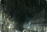
| The eroded valley of lava that erupted from the middle of Geomunoreum is the largest on Jeju Island. On one side is a four-kilometer oval valley. On the southeast ranch site, there are many conical hills with lava detritus, which are volcanic cones without craters. Geomi Oreum in Songdang-ri, Gujwa-eup is also called East Geomun Oreum to distinguish it from this one. Local residents call it either Geomul Chang (Geomeol Chang) or Geomun Oreum since it looks black when covered with forest. However, according to a scholar's etymological study, "Geomun" originates from "Gam" or "Geom" during the ancient Joseon Era which means "God." Therefore, "Geomun Oreum" means "Holy Mountain." The forest is thick with Pinus thunbergii and Japanese cedars. There is a large, horseshoe-shaped crater on top. | |||
Oreum of the Rising Sun, Seongsan Ilchulbong
 |
Address : 272 Ilchul-ro, Seongsan-eup, Seogwipo-si, Jeju-do
|
||
| Seongsan Ilchulbong Tuff Cone was created by hydrovolcanic eruptions 100,000 years ago. The peak was once an island, but it is now connected to Jeju Island, due to the sand and gravel washed ashore from Shinyang Beach. Farmers used to grow crops on it. About 200 varieties of plants and animals live on it. Udo Island is to the north and Seopjikoji is to the south. The peak is a prime spot from which to view the sunrise. It was designated as a natural monument on July 19, 2000; a UNESCO World Natural Heritage site on July 2, 2007; a Global Geopark on October 1, 2010; and one of the New7Wonders of Nature on November 12th, 2011. | |||


|
Room 1010, Renaissance Tower Bldg., 14, Mallijae-ro, Mapo-ku, Seoul, 04195 , Korea Tel. +82-2-714-9064 / Fax. +82-2-714-9084 / diabetes@kams.or.kr 
|
|